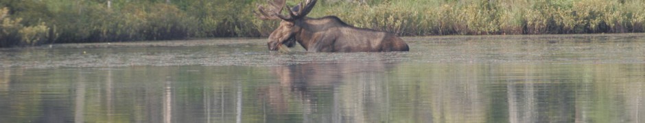

Bull Moose at Helldiver Pond
Summer rainfall shortage could affect Adirondack blackberry crop
We sure could use some rain, as could other parts of the country. The streams and rivers are getting pretty low and I’ve heard of a few wells going dry—something that I hadn’t heard mentioned in several years.
The little sprinkling we got on Sunday hardly made it to the ground. I don’t think it was enough to save the blackberry crop.
If we don’t get some soon they will just be dried up seeds and no fruit. The blueberries I’ve seen don’t look very good either but I think it was the frost in late spring that did them in.
I had several adventures this week, the best being the sighting of the big Bull Moose at Helldiver Pond in the Moose River Wild Forest. It’s had people ohhing and ahhing several mornings in the last couple of weeks.
He’s out there early so don’t expect to see him if you don’t get there until 9 a.m.
Karen and I just got there this morning at 6:30 and he had just gone back into the woods.

White purple-fringed Orchid
He might wander out into the pond during the daytime but the best chance to see him is around daylight or o-dark thirty.
Before visiting the pond he was down the road by the trail head and then down the trail. He is an impressive animal.
I hope if you get an opportunity to see it, take it.
And don’t forget to get some pictures to remember him by.
A group from Blind’s Big Rock Camps on the Petrie Road were out there on four different days and brought some other folks with them to see the animal.
I think they were just as impressed the last day as they were the first day they saw it.
Another adventure I went on was the search for the Broad Lipped Twayblade over near the Tug Hill Wildlife Management Area.
We found this orchid a few years ago but the last couple years Beavers had flooded the area.
We wanted to see if some of the flowers had survived when the area was drained of water.
It didn’t take us long to find several plants that had already flowered and set seeds.

Matt Young and Linda Garrett in a field of orchids
These plants normally bloom about the end of June but this year they may have bloomed a little earlier.
I went in with Matt Young and Charles Ufford and two people from the Tug Hill Commission who were mapping the area with a GPS.
One was Linda Garrett Executive Director from the Tug Hill Tomorrow Land Trust.
They are looking at protecting beautiful places such as these.
We also checked out a couple of open fens along the road nearby to see if any orchids were blooming, and they were.
I saw more small Purple Fringed Orchids than I had ever seen anywhere else.There were hundreds of them and some of them were pure white.
In one spot where Matt stood he counted nearly one hundred.
There were also several Club Spur Orchids, some were the biggest I had ever seen.
There were lots of Round Leaf Sundews, Buckbean and all different kinds of sedges.
Around the edges were several Showy Lady Slippers that had already bloomed and several White Bog Orchids still in bloom. It is a unique and special place.
Some of the parts of the Moose River Wild Forest and the Little Moose Mountain Wilder-ness Area UMP’s have been implemented.
This was in the form of rocks put in the former roads that are now foot and bike trails.
The one that bothers me most is the blockage of the road that goes to Little Indian Lake, past Squaw Lake.
The road is now blocked by three rocks two-tenths of a mile before the Squaw Lake trailhead.
I shouldn’t complain because they wanted to cut off the road at the Moose River Bridge, then the Otter Brook Bridge.
I attended two of the three public hearings on these plans.
The majority of the speakers wanted to keep the road open as it was all the way to the trailhead of Little Indian Lake.
It’s still Wild Forest but they are treating it as wilderness.
One reason for this is the new east west foot trail that goes from the new Crown Point Bridge to North Dakota.
It wasn’t set in stone then and I don’t think it is still. They didn’t want to walk the same dirt roads traveled by cars so DEC tried to give them the whole road as a foot trail and they damn near did.
There were plenty of places the trail could have been made in the existing West Canada Wilderness Area where they did not have to use the road.
But that would have meant cutting a new trail. Why cut a trail when you can use an existing road?
I must be old school, but in Region 6 they make a five-mile-long foot trail into a road to access Woodhull Lake and in Region 5 they make a five-mile-long existing road into a foot trail all in Wild Forest.
They tell me rocks can’t be moved, but I don’t believe it.
When the campers start seeing the campsites by the streams (just about the only ones that are normally used) closed, then you might hear screaming.
Geese lose their ability to fly, but that’s another story.